Marsala - Porto di Marsala - Marsala's port news
HOME VELA NEWS ANNUNCI CHARTERER/NOLEGGIO MEDSEA MAP/MAPPA ARCIPELAGHI PORTI MEDITERRANEO LINKS

Informazioni varie / Port Information
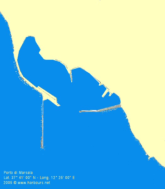
Lat. 37� 41' 00" N - Long. 12� 25' 00" E

Sicilia-Provincia di Trapani Provincia:Trapani
Classe/Cat.:2/II 
Tipo:Pesch./Comm
Area:Canale Sicilia
Lungh.Banch.
Quay length
Fondali
Depth
Superf. Piazz.
Area sq.
Autorit�
Authority
Distr.Carb.
Refuell.
Serv.Idrico
Potable H2O
Serv. Tel.
Phone
Pontili Dip.
Pleasure
N. Posti
boats nr
 750 m  4.5 / 6 m  8.000 mq  GC/GF/PS  si /yes  si / yes   si /yes   200
Circoli Nautici
Pleasure Club
Serv.Elettr.
Electrical
Alaggio
Slip
Celle Frigor.
Cold store
Dogana
Customs
Mezzi Mecc.
Crane serv.
Cant. Nav.
Shipyard
Off.navalmecc.
Workshop
Rimessag.
Dockyard
 3  si / yes  2    si / yes  si / yes  2    


Cartina del porto di Marsala - Marsala's port map / cliccare per l'ingrandimento - please click on to zoom image Furono gli Arabi a chiamarla Marsa Al� (Porto di Al�)per la sua posizione strategica. La sua importanza economica fu mantenuta anche sotto le varie dominazioni che seguirono:Normanna, Sveva, Angioina, Aragonese. Dal 1860 la citt� � ricordata come punto di inizio scelto da Garibaldi per lo sbarco della sua spedizione dei Mille che inizi� la marcia che metteva fine al Regno Borbonico delle Due Sicilie e la conseguente riunificazione dell'Italia. Le strutture portuali sono artificiali � dotato di due moli curvilinei.
Fanali :
- bianco sulla testata del molo di ponente, portata 13 miglia,2 lampi ogni 10"
- verde sulla testata del molo di levante, portata 5 miglia, luce intermittente
- rosso sulla testata della diga foranea, portata 5 miglia, luce intermittente.

Town name originated during the Arab rule Marsa Al� ( Al�'s Port ) for its strategic geographical position in the Mediterranean Sea. The economic importance also was maintaining under the various rules : the Norman, the Swabian, the Angevin. Since 1860 Marsala is recalled for the historic landing of the Garibaldi's expedition to release the Italy nation from Bourbon Kingdom rule. This is an artificial port delimited by two curvilinear quays.
Lights :
- white on Ponent quay head, 13 miles range, 2 flashes every 10 seconds
- green on Levant quay head, 5 miles range, intermittent flashes
- red on outer breakwater head, 5 miles range, intermittent flashes .


E-Mail contact harbours@har-bours.net
Web-Design and Services by © 1999/2005 Internet Network Solutions - Italy/UE - All Rights Reserved